

Latest Weather Blog
Tuesday AM Forecast: Afternoon storms continue, Dry and warmer this weekend
With plenty of warm, humid air in place this week, afternoon storms will continue through midweek. By the weekend, we exchange stormy afternoons for some of the warmest conditions yet of the year.
Here is a breakdown of what to expect
- Tuesday & Wednesday: scattered to numerous afternoon showers and thunderstorms
- Thursday & Friday: drier days - showers more isolated in nature, warmer
- Weekend: very warm and humid, mainly dry & sunny
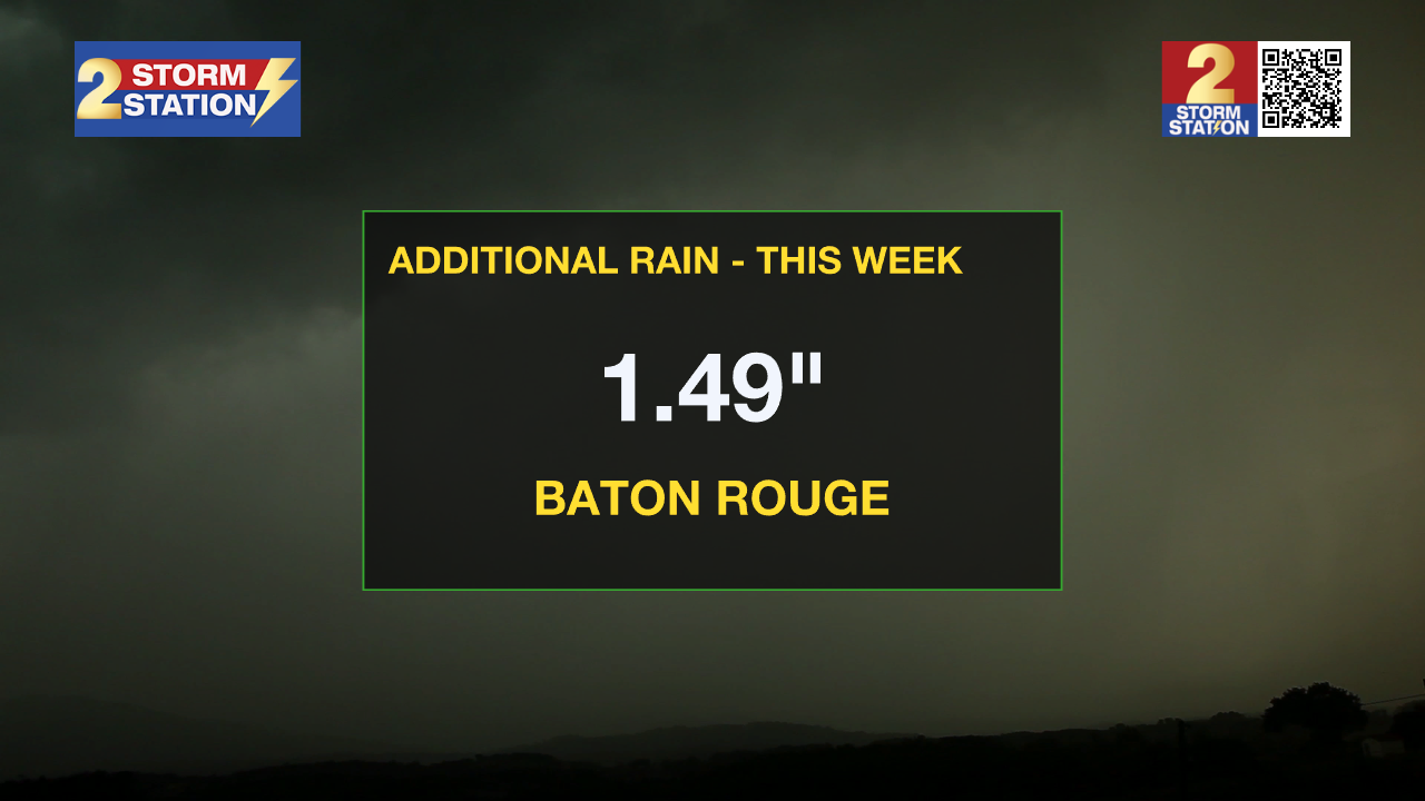
Today & Tonight: Partly sunny skies early Tuesday will warm temperatures into the mid-80s before more storms arrive this afternoon. Similar to Monday, scattered to numerous storms will move through the Capital Region through the afternoon and early evening hours. Around 1-2" of rainfall will be possible with a few isolated instances of higher amounts due to heavy downpours over an extended amount of time. Watch out for standing water on roadways and near poor drainage areas. Overall, 70% of the WBRZ coverage areas should see measurable rainfall today. The entire afternoon will not be a washout.
Tonight, rain chances will dwindle but clouds remain. Another mild and stick morning in the upper-60s should be expected Wednesday.
Up Next: Wednesday will bring similar conditions, with scattered showers and storms through the afternoon. The second half of the workweek features less of a threat for active weather as a ridge of high pressure will build over the region, promoting sinking air and reducing rain chances. Isolated showers are expected Thursday with spotty afternoon shower activity by Friday. Sunshine will make a gradual return, and temperatures will start to rise, with highs climbing into the mid to upper 80s. Warm, muggy nights will persist.
Trending News
Looking ahead to the weekend, the Capital Region will get the first taste of the warm and steamy summer weather that we all know so well. Both Saturday and Sunday are expected to stay mostly dry, with temperatures nearing the 90 degree mark.
River Flooding:
The National Weather Service has issued a RIVER FLOOD WARNING for the Mississippi River at Red River Landing, Baton Rouge, Donaldsonville, and Reserve, as well as the Atchafalaya River at Morgan City until further notice.
• At Red River Landing, flood stage is at 48 feet. Moderate flooding is already occurring. A crest of 59 feet is expected around April 30. At this level, Angola prison farmland between the two levees will be inundated and the east bank levee will be topped. Angola Landing will be under water, closing the ferry. All river islands along the reach from Red River Landing to Baton Rouge will remain inundated with recreational camps and river bottom farmland under water. This gauge will fall below flood stage around May 13.
• At Baton Rouge, flood stage is 35 feet. Moderate flooding is already occurring. Major flood stage will be reached on Thursday, cresting at 41.0 feet on May 1. Around these levels, the grounds of the older part of Louisiana State University's campus become soggy. This includes the area around the Veterinary Medicine building, the Veterinary Medicine Annex, and Alex Box Stadium. Levees protect the city of Baton Rouge and the main LSU campus at this level. Caution is urged when walking near riverbanks. This gauge will fall below flood stage around May 11.

• At Donaldsonville, flood stage is at 27 feet. Minor flooding is already occurring. A crest of 30 feet is expected around May 1—right at moderate flood stage. Around these levels, navigation becomes difficult for smaller river craft. Safety precautions for river traffic are urged. After cresting, the river will fall below flood stage around May 10.
• At Reserve, flood stage is at 22 feet. Minor flooding is forecast to begin Thursday. A crest of 23.5 feet is expected around May 1. Around these levels, slow-bell procedures will be enacted for river transportation. After cresting, the river will fall below flood stage around May 9.
• At Morgan City, flood stage of 6 feet may be reached on Saturday. Moderate flooding with a crest of 7 feet is forecast on May 2. At 7 feet, buildings at the foot of Ann Street on the river side of the flood wall will flood as water overtops the Rio Oil Company dock. Buildings on the river side of the Berwick floodwall will flood. River traffic restrictions will be strictly enforced. In addition, backwater flooding could potentially impact portions of areas around Lake Palourde and Stephensville.
Get the latest 7-day forecast and real-time weather updates HERE.
Watch live news HERE.
– Emma Kate C.
The Storm Station is here for you, on every platform. Your weather updates can be found on News 2, wbrz.com, and the WBRZ WX App on your Apple or Android device. Follow WBRZ Weather on Facebook and X for even more weather updates while you are on the go.
More News
