Sunday PM Forecast: Daily downpours possible at least through midweek
A warm and muggy onshore wind helped to spark spotty showers on Easter Sunday, but the real action picks up into the new week. Many will be dodging rain when going outside for the next several days.
Tonight & Tomorrow: Spotty light showers will not carry too far into the evening. The first part of the night will be muggy and mild with only a few passing clouds. But clouds will return late with a low bottoming out near 70°. A front will stall out to the northwest, keeping moisture in the region and allowing several pieces of energy to slide through.
Rain will be confined to two areas: along the front (northwest of the local area) and downwind of marine sections (i.e., southeast Louisiana marshes, Lake Pontchartrain, Lake Maurepas). Brief, spotty showers are not off the table for the Monday morning drive, especially along and east of Baton Rouge. The coverage of showers and storms should expand throughout the day as the air heats up. While not a washout, there should be a healthy scattering of rain across the region. Umbrellas will be a good accessory. An organized severe weather threat is not expected, but one or two storms might be capable of gusty winds and/or small hail—this will not concern the majority. Rain aside, look for a mixture of clouds and sun with a high in the mid-80s.
Renewed Rain Chances: Rain chances will remain elevated through midweek. Leftover boundaries from Monday’s storms will likely serve as initiation sites for new storm development on Tuesday. Again, a washout is not the expectation; however, be prepared to face scattered activity, especially during the afternoon and early evening. A repeat of this is likely on Wednesday, with the added element of a complex of storms from Texas moving in. That could be an extra piece to the puzzle that boosts rain coverage even more. The latest Storm Station forecast calls for a 60% rain coverage on Tuesday and Wednesday. But further adjustments might be needed, so stay in touch with the forecast.
Up Next: Rain chances will begin to drop off on Thursday and Friday, leading right into the weekend. Gradual clearing will take place as well, but it will still be warm and muggy. In fact, a warming trend will take place. Highs will flirt with the 90° over the weekend.

River Flooding: The National Weather Service has issued a RIVER FLOOD WARNING for the Mississippi River at Red River Landing, Baton Rouge, and Donaldsonville, as well as the Atchafalaya River at Morgan City until further notice.
Trending News
• At Red River Landing, flood stage is at 48 feet. Moderate flooding is already occurring. A crest of 58 feet is expected around April 29. Around these levels, Angola farmland on the left bank begins taking on water. Caution is urged when walking near riverbanks. The river will crest by April 29, then fall below flood stage by May 12.
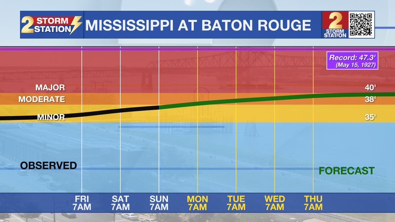
• At Baton Rouge, flood stage is 35 feet. Moderate flooding will likely begin early Monday. Major flood stage will be reached around April 25, cresting around 40.7 feet by April 29. Levels will fall below flood stage around May 9. Around these levels, the grounds of the older part of Louisiana State University's campus become soggy. This includes the area around the Veterinary Medicine building, the Veterinary Medicine Annex, and Alex Box Stadium. Levees protect the city of Baton Rouge and the main LSU campus at this level. Caution is urged when walking near riverbanks.
• At Donaldsonville, flood stage is at 27 feet. Minor flooding is already occurring. A crest of 29.5 feet is expected around April 29—just under moderate flood stage. Around these levels, navigation becomes difficult for smaller river craft. Safety precautions for river traffic are urged. The river will crest by April 29, then fall below flood stage around May 7.
• At Morgan City, flood stage of 6 feet may be reached on Thursday. Moderate flooding with a crest of 7 feet is forecast by May 2. At 7 feet, buildings at the foot of Ann Street on the river side of the flood wall will flood as water overtops the Rio Oil Company dock. Buildings on the river side of the Berwick floodwall will flood. River traffic restrictions will be strictly enforced. In addition, backwater flooding could potentially impact portions of areas around Lake Palourde and Stephensville.
Get the latest 7-day forecast and real-time weather updates HERE.
Watch live news HERE.
-- Meteorologist Malcolm Byron
The Storm Station is here for you, on every platform. Your weather updates can be found on News 2, wbrz.com, and the WBRZ WX App on your Apple or Android device. Follow WBRZ Weather on Facebook and X for even more weather updates while you are on the go.


