

Latest Weather Blog
Monday AM Forecast: Daily rain chances return, Warm and muggy conditions remain
We’re kicking off the week with the return of showers and storms. Keep your raingear handy and a close eye on the radar if you have outdoor afternoon plans. Here's what you need to know:
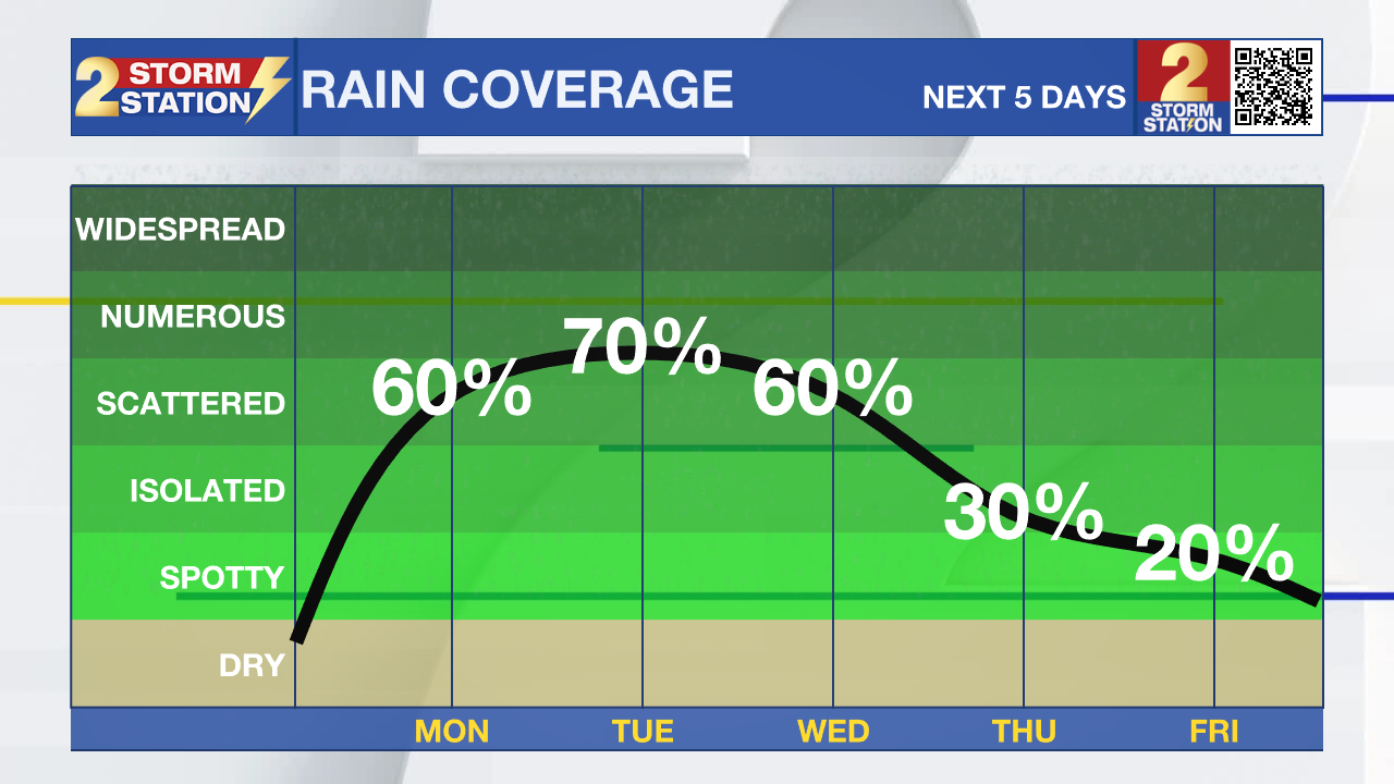
Today & Tonight: Get your umbrella ready if you're heading out today. A warm and humid start to the day with early temps in the low 70s will give way to highs in the middle 80s. Rain chances ramp up this afternoon as scattered shower and storm activity is expected to develop as deep moisture from the Gulf combines with a weak front just to our north. A few storms today could bring gusty winds or small hail, especially north and west of the metro area. A few spots could see brief downpours as well. Tonight, expect temps to settle back into the upper 60s, with lingering light showers possible.
This Week: Tuesday remains unsettled with more rain expected. While no washout expected, around 70% of the Capital Region will see rain at some point on Tuesday. While a few showers could be around during the Tuesday morning commute most of the radar activity will be in the afternoon and early evening. Temperatures stay steady in the mid 80s, and the moisture levels will still be quite high, keeping things sticky. Wednesday will be very similar, will scattered showers and t-storms in the afternoon. It will be warm and muggy all week when not raining.
The second half of the week brings noticeable improvement — Thursday and Friday will still see a few isolated pop-up showers, but sunshine becomes more likely and temperatures will begin to climb in response.
Trending News
Next Weekend: Looking ahead to the weekend? Great news! Both Saturday and Sunday look mostly dry (just a slim 10% chance of rain) with highs climbing to the upper 80s. Perfect timing for any outdoor plans.

River Flooding: The National Weather Service has issued a RIVER FLOOD WARNING for the Mississippi River at Red River Landing, Baton Rouge, and Donaldsonville, as well as the Atchafalaya River at Morgan City until further notice.
• At Red River Landing, flood stage is at 48 feet. Moderate flooding is already occurring. A crest of 58 feet is expected around April 29. Around these levels, Angola farmland on the left bank begins taking on water. Caution is urged when walking near riverbanks. The river will crest by April 29, then fall below flood stage by May 12.
• At Baton Rouge, flood stage is 35 feet. Moderate flooding will likely begin early Monday. Major flood stage will be reached around April 25, cresting around 40.7 feet by April 29. Levels will fall below flood stage around May 9. Around these levels, the grounds of the older part of Louisiana State University's campus become soggy. This includes the area around the Veterinary Medicine building, the Veterinary Medicine Annex, and Alex Box Stadium. Levees protect the city of Baton Rouge and the main LSU campus at this level. Caution is urged when walking near riverbanks.
• At Donaldsonville, flood stage is at 27 feet. Minor flooding is already occurring. A crest of 29.5 feet is expected around April 29—just under moderate flood stage. Around these levels, navigation becomes difficult for smaller river craft. Safety precautions for river traffic are urged. The river will crest by April 29, then fall below flood stage around May 7.
• At Morgan City, flood stage of 6 feet may be reached on Thursday. Moderate flooding with a crest of 7 feet is forecast by May 2. At 7 feet, buildings at the foot of Ann Street on the river side of the flood wall will flood as water overtops the Rio Oil Company dock. Buildings on the river side of the Berwick floodwall will flood. River traffic restrictions will be strictly enforced. In addition, backwater flooding could potentially impact portions of areas around Lake Palourde and Stephensville.
Get the latest 7-day forecast and real-time weather updates HERE.
Watch live news HERE.
- Emma Kate C.
The Storm Station is here for you, on every platform. Your weather updates can be found on News 2, wbrz.com, and the WBRZ WX App on your Apple or Android device. Follow WBRZ Weather on Facebook and X for even more weather updates while you are on the go.
More News
