Sunday AM Forecast: Unsettled pattern emerging after warm and muggy Easter Sunday
Easter Sunday will be warm, muggy, and mostly dry, with just a few spotty showers possible. Next week turns more unsettled, with increasing rain chances and the potential for thunderstorms as multiple systems move through the region.
Today & Tonight: Easter Sunday will be warm and muggy, with mostly cloudy skies all day long. High temperatures will top out in the mid 80s, which is about five degrees above average for this time of year. Increasing moisture content in the atmosphere will lead to some spotty showers, especially in the afternoon and evening. These will be very light, and also not many will form. For that reason, outdoor plans will be good to go! Tonight, lows will be near 70 degrees. Spotty showers will remain possible.
Up Next: A system currently making its way through the Southwest will begin to influence our weather as we head into early next week. On Monday, numerous showers are expected, with a few thunderstorms also possible. While it doesn’t look like a total washout and little to no severe weather is anticipated at this time, it’s still a good idea to have the umbrella nearby. This wet pattern is being driven by a weak front that’s expected to stall, combined with abundant moisture and just enough atmospheric lift.
After Monday, the forecast becomes more uncertain—but also more intriguing. Gulf moisture will continue to stream into the region, keeping things warm and muggy. Starting Tuesday and lasting into the weekend, several disturbances may pass through Texas and the Lower Mississippi Valley. Each of these systems could trigger rounds of showers and storms, but their exact timing and strength remain up in the air. Even subtle shifts could have a big impact, so we’ll be keeping a close eye on how things evolve.

Trending News
River Flooding:
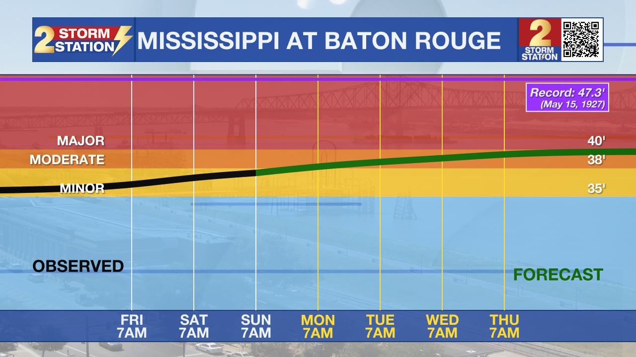
The National Weather Service has issued a RIVER FLOOD WARNING for the Mississippi River at Red River Landing and Baton Rouge, as well as the Atchafalaya River at Morgan City until further notice.
• At Red River Landing, flood stage is at 48 feet. Moderate flooding is already occurring. A crest of 58 feet is expected around April 29. Around these levels, Angola farmland on the left bank begins taking on water. Caution is urged when walking near riverbanks. The river will crest by April 29, then fall below flood stage by May 12.
• At Baton Rouge, flood stage is 35 feet. Moderate flooding will likely begin early Monday. Major flood stage will be reached around April 25, cresting around 40.7 feet by April 29. Levels will fall below flood stage around May 9. Around these levels, the grounds of the older part of Louisiana State University's campus become soggy. This includes the area around the Veterinary Medicine building, the Veterinary Medicine Annex, and Alex Box Stadium. Levees protect the city of Baton Rouge and the main LSU campus at this level. Caution is urged when walking near riverbanks.
• At Morgan City, flood stage of 6 feet may be reached on Thursday. Moderate flooding with a crest of 7 feet is forecast by May 2. At 7 feet, buildings at the foot of Ann Street on the river side of the flood wall will flood as water overtops the Rio Oil Company dock. Buildings on the river side of the Berwick floodwall will flood. River traffic restrictions will be strictly enforced. In addition, backwater flooding could potentially impact portions of areas around Lake Palourde and Stephensville.
Get the latest 7-day forecast and real-time weather updates HERE.
Watch live news HERE.
– Balin
The Storm Station is here for you, on every platform. Your weather updates can be found on News 2, wbrz.com, and the WBRZ WX App on your Apple or Android device. Follow WBRZ Weather on Facebook and X for even more weather updates while you are on the go.


