

Latest Weather Blog
Sunday PM Forecast: Grabbing the jacket early, losing it later, with no rain to worry about
More chilly nights are in the Storm Station forecast. Plan on jacket weather each morning, but abundant sunshine will warm things right back up each afternoon. Meanwhile, very dry air will keep the area rain-free for the next week.
Tonight & Tomorrow: Mostly clear skies and light overnight winds will allow daytime heat to escape quickly, leading to another chilly morning across the Capital Area. Though slightly warmer than Sunday morning, wake-up temperatures will still drop into the upper 40s to low 50s. That’s cool enough to require a jacket on the journey to work or school. However, that extra layer might not be necessary for the commute home. Ample sunshine will boost temperatures into the low 70s by lunchtime, on the way to a high near 78° by mid-afternoon.

Up Next: Though temperatures will gradually moderate over the rest of the week, mornings will stay on the chilly side in the low-to-mid-50s. Meanwhile, afternoon highs will climb into the mid-80s by midweek before flirting with the upper 80s by the week’s end. This large gap between daytime highs and overnight lows is driven by a very dry air mass, which heats and cools much faster. The dry air will also shield the Capital Area from any rain whatsoever for the next week.
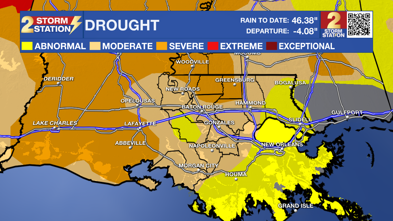
With drought conditions worsening in recent weeks, the lack of rain is an ongoing concern. Dry vegetation does increase the risk of grass fires, so please exercise caution when burning, even in the absence of an official Red Flag Warning.
Trending News
Get the latest 7-day forecast and real-time weather updates HERE.
Watch live news HERE.
The Tropics: A non-tropical area of low pressure is expected to form off the southeast coast of the United States by Monday. The system will produce tropical-storm-force winds. Should the disturbance detach from fronts and begin acquiring energy from the warm Gulf Stream, subtropical development would be possible. A subtropical storm is a hybrid system of sorts that draws power from both warm ocean water and the clash of warm/cool air in the atmosphere.

Regardless of development, the storm will cause high winds, coastal flooding, and dangerous surf along parts of the East Coast. The next name up is Josephine.
— Meteorologist Malcolm Byron
The Storm Station is here for you, on every platform. Your weather updates can be found on News 2, wbrz.com, and the WBRZ WX App on your Apple or Android device. Follow WBRZ Weather on Facebook and X for even more weather updates while you are on the go.
More News

