

Latest Weather Blog
Sunday AM Forecast: Rain coverage trending lower today, high chance of development in tropics
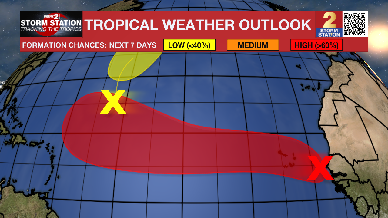
Clouds may limit storm development today, though a few could still bring downpours and gusty winds. A tropical wave off Africa now has a high chance of developing but poses no immediate local threat.
Today & Tonight: Morning observations show some new factors that could significantly impact today’s forecast. Numerous coastal thunderstorms have spread a blanket of clouds over southeast Louisiana, which may limit daytime heating—and in turn, reduce storm development later on. While the earlier forecast called for scattered storms, isolated activity now seems more likely. Any storms that do form could still produce downpours, lightning, and gusty winds. Highs will top out in the lower 90s under mostly cloudy skies.
Up Next: Tropical moisture sticking around will fuel a daily dose of scattered storms through at least midweek. The bulk of the action will arrive in the afternoons, which could slow down the ride home or interfere with after-school plans. Temperatures will hold steady, with highs in the low 90s and lows in the mid-70s. By late week, rain chances will ease and storms will become more isolated. As the skies dry out, afternoon highs will creep back into the mid-90s heading into the weekend.
The Tropics: In classic August fashion, the Atlantic is starting to heat up. The main feature to watch right now is a tropical wave just off Africa’s west coast, where conditions look favorable for development. Chances are growing for this disturbance to become a tropical depression, potentially by tonight or on Monday as it moves west across the tropical Atlantic.
Looking farther ahead, the system’s eventual path is still highly uncertain. Forecast confidence will stay low until a storm actually forms. At this point, there’s no threat to our area, and any possible U.S. impacts would be more than 10 days out—assuming it doesn’t curve harmlessly out to sea. For now, it’s simply a system worth keeping an eye on.
Trending News
Meanwhile, another tropical wave is located in the central tropical Atlantic. Development odds are decreasing with this system. Tropical development now appears unlikely due to surrounding dry air.
Get the latest 7-day forecast and real-time weather updates HERE.
Watch live news HERE.
— Balin
The Storm Station is here for you, on every platform. Your weather updates can be found on News 2, wbrz.com, and the WBRZ WX App on your Apple or Android device. Follow WBRZ Weather on Facebook and X for even more weather updates while you are on the go.
More News
