

Latest Weather Blog
Monday PM Forecast: week of weather whiplash with back and forth temperatures, storms
Many frontal passages will result in a period with highly variable temperatures and a few rounds of storms. The Capital Area might even be facing a few rounds of severe weather.
Tonight & Tomorrow: After a relatively cooler and comfortable afternoon, a warm front will change things up for Tuesday. Overnight lows will trend warmer as a result, with lows in the low to mid-60s as opposed to the 50s felt in spots early Monday. Skies will become mostly cloudy as the warm front slides into the region, and there may be some patchy fog on Tuesday morning.
Expect a mixture of clouds of sun for the rest of the day. Look for a high near 83° in Baton Rouge – easily challenging the record of 81° (2024, 2017, 1999). A persistent south wind behind the warm front could lead to spotty showers as things heat up. By late afternoon, an axis of thunderstorms will form along the warm front. But by this time, the front will likely be north of Baton Rouge. Areas along and north I-10/12 have the potential of being clipped by these storms anywhere from late Tuesday afternoon through the evening. Spots closer to the coast will have a harder time picking up rain.
Up Next: The Capital Area will remain warm and muggy on Wednesday, giving the atmosphere time to recharge. Numerous thunderstorms will take advantage of an energized atmosphere by mid-to-late afternoon, lasting into the evening. Some storms could be strong (see below). A cold front will sweep the rain out late Wednesday, leading to a cooler Thursday and Friday with smaller rain chances. The week will culminate with a one-two frontal punch on Saturday. A morning warm front will heat things up ahead of a late cold front. In between, another round of showers and storms is likely. Again, some storms could be strong (see below). All told, 1-3” of rain is expected in the next week.
Trending News
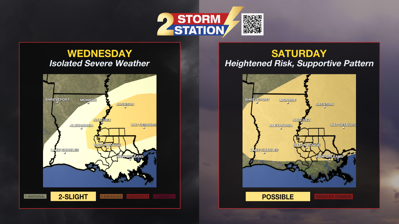
Severe Weather Odds:
Wednesday – Being the second straight day with warmth and mugginess, the atmosphere will be energized. But one thing that will be lacking is strong support in the upper atmosphere. For this reason, afternoon storms should develop but struggle to become significantly stronger. Nevertheless, one or two rogue storms could intensify to severe limits. Damaging winds, hail, and a brief spin-up would be a possibility with those. Then during the evening, a cold front will trigger a broken line of storms around or shortly after dark. Damaging winds are the primary concern with these, but a brief tornado is not out of the question.
While there will be a few variables out of place, Wednesday could bring a sneaky severe weather threat if individual storms can find a favorable environment. There is a Level 2/5 risk for severe weather on Wednesday mainly north of I-10/12. That would indicate a potential for isolated severe weather reports.
Saturday – Being several days out, there are still a lot of unknowns with how everything plays out on Saturday. There is support for a rather potent upper-level disturbance swinging through the region. If it takes the right track, most variables would be in place for what could be a bigger severe weather threat. The Storm Prediction Center highlights much of the area as having the potential for severe weather on Saturday. Details should come into focus later in the week as the responsible disturbance moves over the West Coast.
Get the latest 7-day forecast and real-time weather updates HERE.
Watch live news HERE.
-- Meteorologist Malcolm Byron
The Storm Station is here for you, on every platform. Your weather updates can be found on News 2, wbrz.com, and the WBRZ WX App on your Apple or Android device. Follow WBRZ Weather on Facebook and X for even more weather updates while you are on the go.
More News
