

Latest Weather Blog
Friday AM forecast: Warm and breezy Friday before weekend rain and storms move in
A warm and breezy Friday before rain and storms arrive this weekend.
Today & Tonight:
After a cool start, temperatures continue to climb under partly to mostly sunny skies. Afternoon highs reach the lower to mid-80s across the Capital Region with light southerly winds helping moisture return to the area. Conditions will stay mainly dry through the day, though a few clouds may increase late as humidity rises. Tonight will feel warmer and more humid than recent nights, with lows in the 60s and patchy fog possible before sunrise. Area high school football should be fine.
This Weekend:
The weekend will start dry for most areas early Saturday morning. By afternoon, clouds increase from the west as a strong upper disturbance and surface front approaches from Texas. Showers and a few storms will begin developing west of Baton Rouge during the day Saturday, spreading eastward Saturday night into Sunday. Overnight thunderstorms could be heavy.
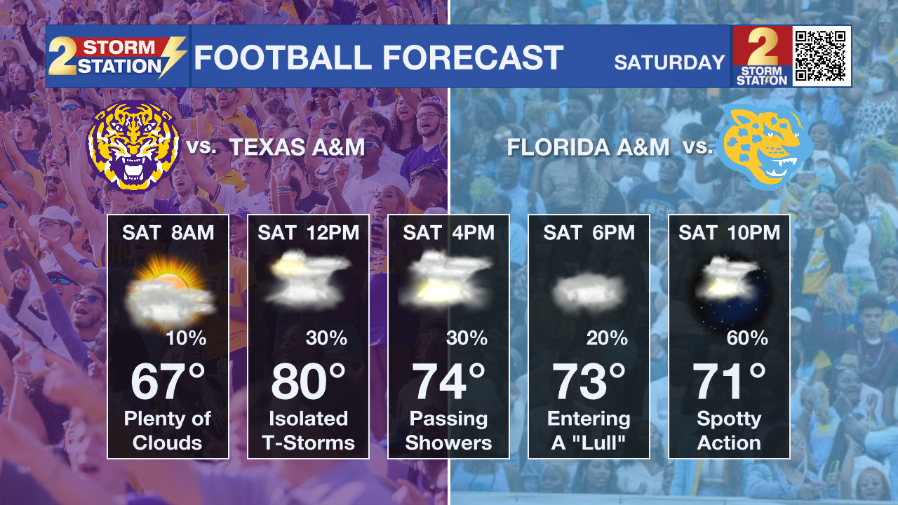
If you’re planning to tailgate or head to either game in Baton Rouge, the Southern Jaguars kick off at 4:00 p.m. and LSU plays under the lights at Tiger Stadium at 6:30 p.m. Most of the morning looks okay, with temperatures in the 80s through midday. However, some showers and storms could begin approaching the area by mid-afternoon, so it’s worth keeping an umbrella or poncho handy just in case activity moves in a bit sooner than expected.
Trending News
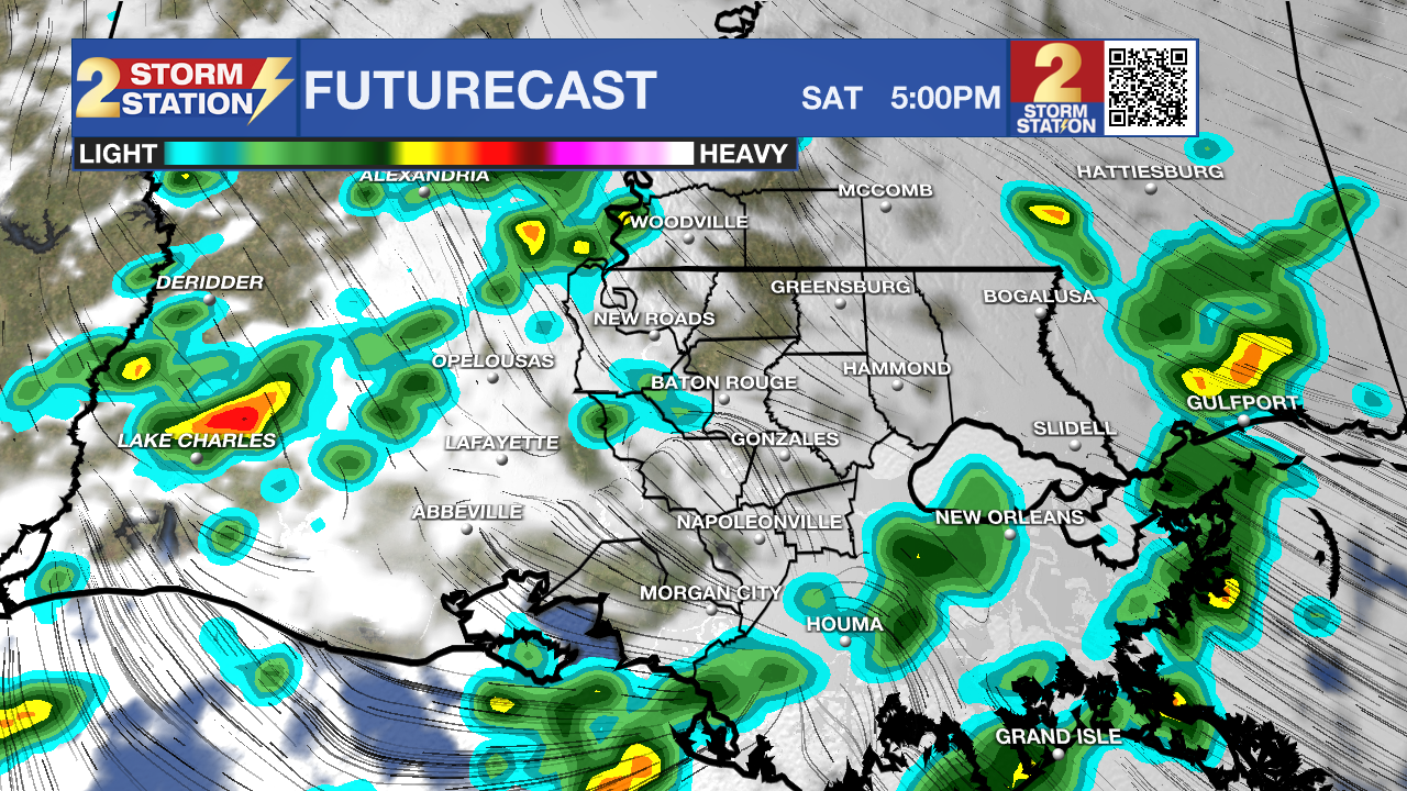
Rain will become more widespread and locally heavy at times Saturday night through midday Sunday. Totals around 1 to 3 inches are expected for most of the region, with isolated higher amounts possible in heavier downpours. The ground is fairly dry, so widespread flooding issues are not expected, though poor drainage areas could briefly see ponding on roads.
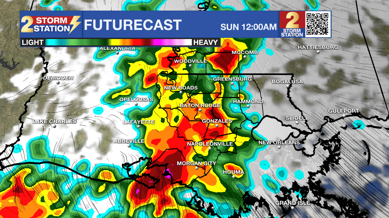
A few stronger storms can’t be ruled out late Saturday night into Sunday morning, mainly near and north of the I-10/12 corridor. Gusty winds and frequent lightning will be the main threats. Behind the front, cooler and drier air arrives Sunday evening with a pleasant start to next week. Another stronger front is possible around midweek, potentially ushering in the coolest air of the season just in time for Halloween.
Tropics:
Tropical Storm Melissa continues to organize over the central Caribbean Sea. Winds are now near 45 mph, and environmental conditions are becoming more favorable for strengthening. Melissa is expected to become a hurricane within the next 48 hours and could rapidly intensify into a major hurricane by late this weekend or early next week.
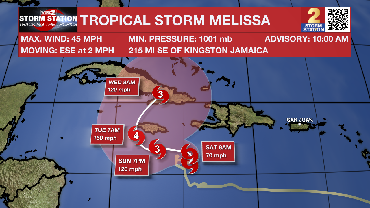
Melissa is forecast to drift slowly northward before turning west, bringing a prolonged period of heavy rain, flooding, and damaging winds to Jamaica as early as Friday night and lasting through the weekend. Strong winds could also impact southern Haiti and eastern Cuba. This will be a large and dangerous hurricane over the Caribbean in the coming days, and residents in Jamaica, Haiti, and Cuba should continue to monitor the latest forecasts closely.
Get the latest 7-day forecast and real-time weather updates HERE.
Watch live news HERE.
– Dave
The Storm Station is here for you, on every platform. Your weather updates can be found on News 2, wbrz.com, and the WBRZ WX App on your Apple or Android device. Follow WBRZ Weather on Facebook and X for even more weather updates while you are on the go.
More News
